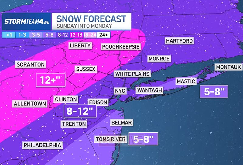
A monster winter storm is expected to sweep across much of the U.S. through this weekend, dumping up to 12 inches of snow onto the New York City area and creating difficult conditions across the country, as areas unaccustomed to snow stare at one of the most intimidating forecasts in some time.
Forecasters are predicting one of the biggest snowstorms for New York City in recent years. The last time Central Park saw over 12 inches was in early February 2021, when over 17 inches fell.
A Winter Storm Watch is in effect from Sunday into Monday, and a Cold Weather Advisory in effect from Friday night through Saturday morning.
Heavy snow is likely late Saturday night into Sunday night, with snowfall rates that could be intense at times. Near the coast, snow may mix with sleet Sunday evening and overnight.
The National Weather Service says Residents should prepare for a major winter storm that could significantly disrupt travel and daily routines, particularly on Sunday and into Sunday evening, with reduced visibility and near whiteout conditions possible.
In New York City, Mayor Zohran Mamdani, facing the biggest test of his administration to date, says the city is preparing for anywhere from 3 to 12 inches of snow. Citywide pre-snow treatment starts Friday to mitigate snow and ice impacts. Two thousand sanitation workers start 12-hour shifts on Saturday.
In addition to the snow, the region is expected to experience a prolonged period of very cold air starting tonight and lasting through late next week. Officials are urging residents to prepare for possible impacts to infrastructure due to the extended cold.
Gale conditions are possible from Sunday into Monday, with moderate freezing spray expected tonight into Saturday morning. Minor coastal and shoreline impacts are also possible during high tides Sunday night.
With the storm still about two days away, forecasters note that there is still uncertainty regarding the exact track, timing, and strength of the system. Details on snowfall amounts and wintry precipitation may change, and updated forecasts will be issued over the next 48 hours.
Residents are encouraged to stay alert and continue monitoring official forecasts and updates from the National Weather Service, NOAA Weather Radio, and local news outlets for the latest information as the storm approaches.
🥶An arctic cold front moves through later today allowing temperatures to plummet tonight to the single digits across much of the area. Wind will make temperatures feel between -5 and -15 degrees tonight into early Saturday AM. Cold weather advisories are in effect. pic.twitter.com/294qpv7xmZ
— NWS New York NY (@NWSNewYorkNY) January 23, 2026
Winter storm watch issued for entire forecast region for late Saturday night through Monday afternoon for heavy snow potential of 6 to 12 inches with some snow accumulations over 12 inches possible. See more here in this text product, https://t.co/iDiDwXWmTX. #NYwx #NJwx #CTwx pic.twitter.com/KgNCuZBFlw
— NWS New York NY (@NWSNewYorkNY) January 22, 2026


On one hand it says 5-8 and in the description its written 12. Big difference
What’s the big deal.
It’s winter.
What do you expect.
Come to the Midwest, their you’ll see REAL winter!!!!!!!!!
Take a chill, it doesn’t happen to often!
Global Warming at it’s finest.
Can get we a monster shofar blow
Thx
No big deal to whom?
It was in the mid-80’s,
when we had at
least 2 feet of snow one day.
So, 12 inches – Nisht
azoy geferlach.
will flights be canceled for kinus hashluchim for woman
That’s in a very long time